


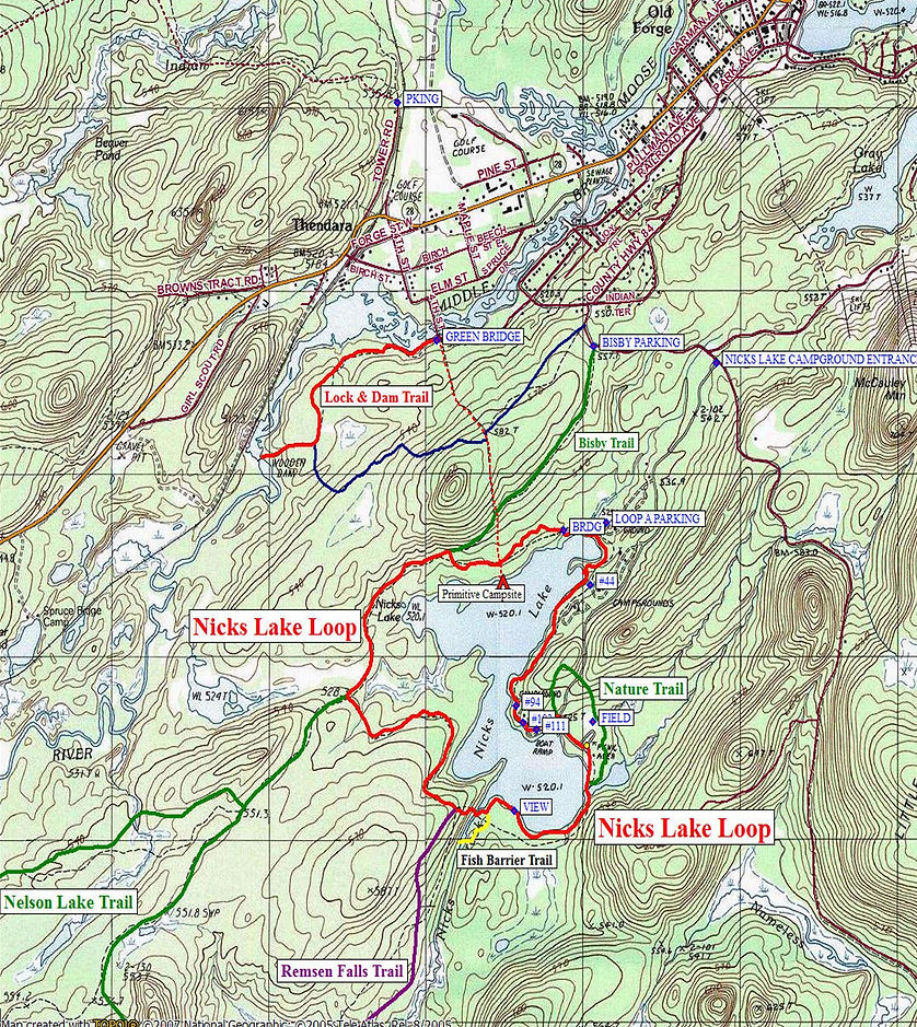
Nicks Lake Loop
A popular hike at Nicks Lake State Campground is the 4.5 mile Nicks Lake Loop. The campground and this trail is located in the Black River Wild Forest of Adirondack Park. The hike is a pleasant, easy walk on a gentle grade except for one steep climb just past the bridge over Nicks Creek (if you're hiking the loop clockwise). The overall elevation gain for this hike is 154 feet, with about 100 feet of that accent at that one steep section.
The GPS coordinates for the entrance of Nicks Lake State Campground is N43 41.606 W74 58.596 for those who have a GPS devise in their vehicle. If your not camping at Nicks Lake, there is a $10 (as of 2012) entrance fee to enter the campground for day use. You can start your hike from Bisby Road, which will add another two miles on your loop hike by utilizing the one mile long Bisby Trail (6.5 miles total hike). The GPS coordinates for the Bisby Road Trail parking area is N43 41.655 W74 59.179, which is marked with a DEC sign along the road.
The description of this loop hike begins at the beach/picnic area parking lot. Park your vehicle in this large parking area and begin your hike by walking towards the beach. The trail actually crosses the beach and travels next to the lake. At 0.1 miles you'll reach the junction of the Nicks Lake Nature Trail on your left and soon after cross the inlet of the lake on a nice bridge, then cross a wetland area on a boardwalk.
The trail now follows the southern shore of Nicks Lake on a well worn trail. There are views of the lake at different vantage points as you walk along the trail. At 0.3 miles cross a small stream on a bridge. The trail area around the bridge tends to be muddy in spots. At 0.6 miles is a real nice view point that overlooks the lake, looking east back at the beach area. At 0.7 miles reach the unsigned junction of the red marked Fish Barrier Dam Trail. The side trail leads 0.2 miles to an old fish barrier dam on Nicks Creek. Worth a side trip if you've never seen one of these before (just be careful not to lose sight of this lesser traveled trail).
At 0.8 miles reach the bridge over Nicks Creek, which is the outlet of the lake. If you look to your right, upstream, you'll see Nicks Lake. This will be the last time you see the lake for awhile. The trail now makes a short, steep climb of about 100 feet in elevation and at 0.9 miles reach the signed junction of the yellow marked Remsen Falls Trail, which could be used for longer backpacking trips. The trail leads 3.8 miles to the Remsen Falls Lean To. The Nicks Lake Loop turns right at this junction.
The Nicks Lake Loop Trail is no longer a narrow hiking path, it is now a wide multi-use trail. The trail descends from the short steep climb, passes a wet area and at 1.65 miles turns veers right (where an old logging road goes left). At 1.7 miles the trail crosses a small stream. At 1.8 miles reach the signed junction of the blue marked Nelson Lake Loop Trail on the left. The Nicks Lake Loop Trail turns right at this junction. The Nelson Lake Loop is another option for a longer backpacking adventure in the Black River Wild Forest.
At 2.55 miles the trail reaches a signed junction where the blue marked Bisby Trail goes straight one mile to the Bisby Road parking area. This is the optional starting point for those not camping at Nicks Lake and not wanting to pay the $10 entrance fee. The Nicks Lake Loop Trail turns right and gently descends. The trail again becomes a narrow hiking path. At 2.8 miles reach the unsigned junction of an unmarked trail that crosses the Nicks Lake Loop Trail. Left the unmarked trail goes to the Bisby Trail in 0.2 miles. Right the unmarked trail descends 0.1 miles to a primitive campsite on the shore of Nicks Lake.
The Nicks Lake Loop Trail continues straight ahead, although it begins to meander as it now reenters the state campground property. You may notice some huge white pines in this area. At 3.2 miles cross a bridge and then ascend. Soon map kiosk and JCT of trail on left that leads to Loop A parking. In a short while the trail crosses a small stream on an old bridge. A side trail on the right leads a short distance to a small sandy beach in a cove on Nicks Lake.
The trail passes by campsite #44 on the left with the lake on your right at 3.5 miles. This stretch of the trail can be hard to follow as you pass campsites on your left. A tough stretch to follow is where the trail passes by a pump house. At 4.1 miles the trail passes a huge boulder and reaches the Loop E Road of the campground near site 94. Turn right and follow the camp road.
At 4.3 miles reach the main campground park road and turn right, following the road. Soon pass a boat launch site on the right and at 4.5 miles reach the beach parking area, which marks the end of this great loop hike. There are plenty of picnic tables to enjoy a picnic as you wind down from your enjoyable hike.
Download The Map